Frequently Asked Questions on Weather for inReach
Compiled below is a list of frequently asked questions about weather for inReach® devices:
Which Apps and Devices Are Compatible With inReach Weather?
Earthmate® App
The following devices are compatible with inReach weather and can also provide weather data to the Earthmate app when connected via Bluetooth® wireless technology.
inReach Explorer® and inReach Explorer®+
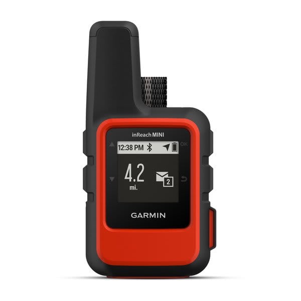
inReach Mini
inReach SE® and inReach SE®+
Garmin Explore™ App
The following devices are compatible with inReach weather and can also provide weather data to the Garmin Explore app when connected via Bluetooth.
Alpha® 200i
Alpha 300i
GPSMAP® 66i, 67i, 86i, and 86sci
inReach Messenger Plus
inReach Mini 2
Montana® 700i and 750i
Garmin Messenger™ App
The following devices are compatible with inReach weather and can also provide weather data to the Garmin Messenger app when connected via Bluetooth.
Alpha 200i
Alpha 300i
GPSMAP 66i, 67i, 86i, and 86sci
inReach Messenger
inReach Messenger Plus
inReach Mini 2
Montana 700i and 750i
Tread® Devices
The following devices are compatible with inReach weather.
Tread - Overland Edition GPS navigator
Tread - SxS Edition GPS navigator
Tread XL - Baja Chase Edition GPS navigator
Tread XL - Baja Race Edition GPS navigator
Tread XL - Overland Edition GPS navigator
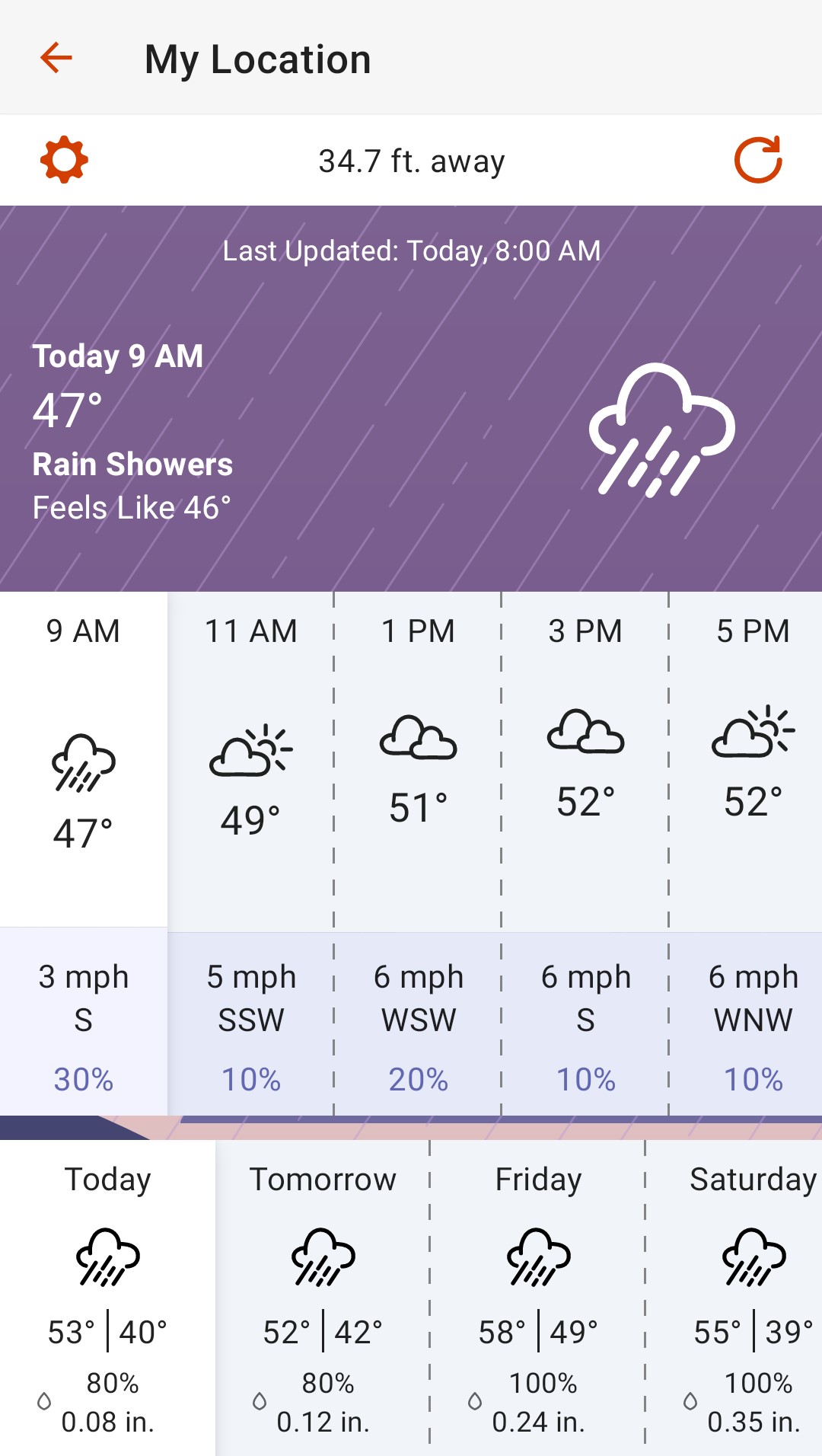
What Is the Difference Between a Basic and Premium/Extended Forecast?
The two differences between a Basic and a non-marine Premium/Extended forecast are the level of detail and length of the forecast. All forecast types have the same cost associated with them (see - How Much Does a Weather Forecast Cost? ).
App/Devices | Basic 2-4 Days of Forecast Data | Premium/Extended 7-8 Days of Forecast Data |
|---|---|---|
| Earthmate app and compatible devices | 36-hour forecast at 2-hour intervals for the first 12 hours, then 6-hour intervals for the next 30 hours. | 7-day forecast reported in varying intervals (every 1-2 hours for the first day, every 3-6 hours for the next day, and every 12 hours for the remaining 5 days). |
| Garmin Explore app and compatible devices | 4-day forecast with the first 24 hours reported in 2-hour intervals, then daily summaries for the next 3 days. | 8-day forecast with the first 48 hours reported in 2-hour intervals, then daily summaries for the next 6 days. |
| Garmin Messenger app and compatible devices | 4-day forecast with the first 24 hours reported in 2-hour intervals, then daily summaries for the next 3 days. | 8-day forecast with the first 48 hours reported in 2-hour intervals, then daily summaries for the next 6 days. |
| Tread devices | 4-day forecast with the first 24 hours reported in 2-hour intervals, then daily summaries for the next 3 days. | 8-day forecast with the first 48 hours reported in 2-hour intervals, then daily summaries for the next 6 days. |
NOTE: 1-2 hour intervals are not available outside of North America. With up-to-date software, the GPSMAP 67i, inReach Messenger Plus, and Montana 700i/750i have a single weather forecast option which provides both premium/extended forecast data and marine forecast data, if available.
The following example is from the Garmin Explore app. For other examples, refer to the device or app you are requesting weather from under
Related
.
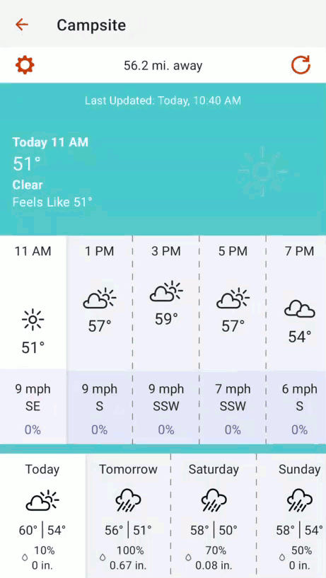
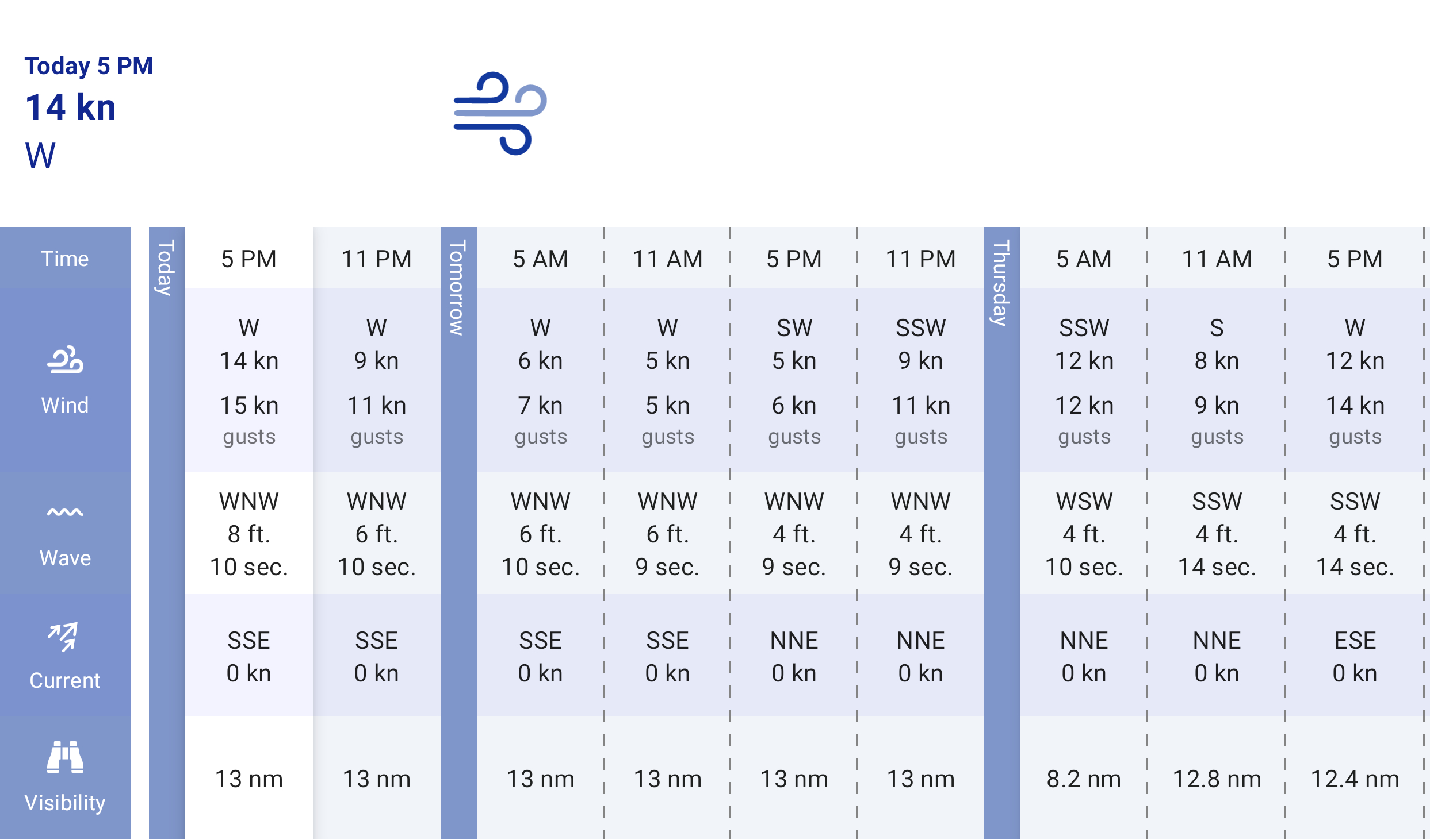
What Additional Information Does a Marine Forecast Include?
Basic + Marine forecasts include 6-7 days of marine forecast data at 6-hour intervals. In addition, Basic + Marine forecasts also include wave height, ocean current, and visibility details. These forecasts also include Basic land forecast information (see above for information on non-marine forecasts).
Premium/Extended + Marine forecasts include 6-7 days of marine forecast data at 6-hour intervals. In addition, Premium/Extended + Marine forecasts also include wave height, ocean current, and visibility details. These forecasts also include Premium/Extended land forecast information (see above for information on non-marine forecasts).
NOTE: A marine forecast will be included for locations on an ocean or other large body of water, if available. If you are unable to get a marine forecast, select a location further from shore. With up-to-date software, the GPSMAP 67i, inReach Messenger Plus, and Montana 700i/750i will automatically request marine forecast data with all weather forecasts.
The following example is from the Garmin Explore app. For other examples, refer to the device or app you are requesting weather from under
Related
.
How Much Does a Weather Forecast Cost?
All types of weather forecasts have the same cost of 1 text message against your plan per request.
Prior to September 18, 2024, both the Annual and Freedom versions of Safety, Recreation, and Expedition plans had higher costs for premium/extended and marine weather forecasts. These plans are no longer available to purchase, but for those customers who are still on one of the old plans, the cost for weather is now the same as it would be for our new plans (1 text message against your plan per request for all forecast types).
How Do I Pay for Weather Forecasts?
Weather forecast charges are automatically added to your next inReach invoice.
Where Does the Weather Data Come From?
Land forecasts are powered by meteoblue, a leading provider of weather data around the globe. The forecasts are based on a multi-model approach , which combines various weather models with current measurements and observations as available, specifically for the location and elevation requested. The meteoblue website provides extensive additional weather information.
Marine forecasts are based on OCENS premium marine weather data which provide wave and wind levels to 1/100th of a degree lat or lon. Atlantic data sources include WW3 Multi-Global, WW3 Navy, NDFD, ECMWF, GFS Global Wave as well as HRRR and RAP for wind in some areas. For further questions on data sources, contact OCENS directly - https://www.ocens.com/support.
What Do the Icons in a Weather Report Mean?
Most of the icons you may receive in an inReach weather report are included below. Be advised that if a weather report contains multiple status (i.e. both Windy and Snow) the icon for the most severe weather event will be shown.
NOTE: Multiple examples are provided for each weather condition as the icons can vary between different apps and devices.
Weather Icons
Clear Day
![]()
![]()
![]()
![]()
Clear Night
![]()
![]()
![]()
![]()
Partly Cloudy Day
![]()
![]()
![]()
![]()
Partly Cloudy Night
![]()
![]()
![]()
![]()
Cloudy
![]()
![]()
![]()
![]()
Fog or Haze
![]()
![]()
![]()
![]()
Rain
![]()
![]()
![]()
![]()
Thunderstorms/Lightning
![]()
![]()
![]()
![]()
Snow
![]()
![]()
![]()
![]()
Sleet, Hail, or Wintery Mix
![]()
![]()
![]()
![]()
Windy
![]()
![]()
![]()
![]()